47. Day 42 – To John O’Groats and Dunnet Head, the northern tip of Scotland
Wednesday 22 November 2006
We couldn’t believe it – we woke to sunshine. 39° Fahrenheit, sunny nevertheless, with a few showers into the distance.
Service Station at Evanton where we stayed overnight
We got going at 8.45am and drove through beautiful Scottish countryside with hay bales, sheep, small towns and the winding drives running off to hidden castles.
GolspieBrora
The road towards John O’Groats follows closely to the coastline. Every time we passed a truck, the driver would flick the vehicle’s lights at us. It appears that it is a code to say that we have passed and the driver has recognised that we can pull in.
A9 running along the coastPortgowerDocks at HelmsdaleTravelling along the coastOusdaleThatched roof shed at Dunbeth
We passed beautiful little stone cottages and the towns on the way to Wick were cute, but Wick itself we found to be out of place, it was modern!
Wick
We found Keiss Castle beside the road. This was the Castle we had flown over on our Sikorsky flight around the world and its photo appears in our book “Above the World”. We drove back along the road a short distance to Keiss Harbour and then went for a walk towards the ruins of the Castle. On the way, we passed a World War II bunker. These bunkers completely surrounded the United Kingdom, no doubt the home guards spent many boring hours looking out to sea!
KeissKeiss CastlePhoto of Keiss Castle from our book Above The WorldRuins of Keiss Castle
As we walked, back from the Castle it poured with rain, luckily we had taken our umbrellas with us. At least we’d had a few hours of sunlight.
Back into the Earthroamer and we were soon at John O’Groats cold and wet. We had coffee and a couple of Scottish shortbread biscuits to get warm.
Dick and Pip at John O’Groats
We met a Russian, Dimitry Tashkin. He was dressed in camouflage and he had driven his vehicle from Moscow. He said that he owned a couple of private aircraft in Moscow. We imagined he would have been one of the nouveau rich benefiting from capitalism.
We parked outside the John O’Groats Inn because it is the finish line for people who run, hop, skip or recently walk nude from Lands End!
John O’Groats Inn start/finish lineJohn O’Groats Inn
After an hour or so at this historic place we decided to head to the true northern tip of Scotland and of Great Britain, – Dunnet Head. With another 45 minutes driving we parked at the car park. Once again we had taken a photograph of Dunnet Head from our Sikorsky helicopter. We walked to the cliff edge, took photos of the lighthouse, and jumped back into the Earthroamer, and warmed up on soup and bread for lunch.
Dunnet Head car park and lighthouseAerial photo of Dunnet Head from our book Above The WorldDick standing above the cliff at Dunnet Head
Dick turned on the TV set; we’ve had no satellite television since America, hard times, but the local TV worked well.
On the way south from Dunnet Head, we stopped and photographed a beautiful highland cow and calf beside the road.
Highland cow and calf
Our GPS showed that our moving average was 31.5 miles per hour from Lands End and that we had done 72 miles per hour for our maximum and our moving time was 45 hours 47 minutes for 1,461.2 miles.
We passed the beautiful and small Thurso Castle and then a large wind farm near Cors Mine. We took a different route this time on the A9 down south heading towards Boyd & Jo Ann Munro’s castle in southern Scotland.
Thurso CastleCauseymine Wind Farm
At Golspie we drove into Dunrobin Castle, amazing that we could get in, as it seemed to be privately owned. Before anyone could come and confront us, we drove back out again onto the A9.
Dunrobin Castle
We could smell coal burning in the homes for heating. This is a smell that Dick could remember from the 1950s in Sydney – long disappeared in Australia.
During our driving in Scotland, military jets would fly over at very low altitude and at this point two Hercules flew over low. There is quite a lot of military activity in this area.
At 4.30pm it was almost dark and 35° Fahrenheit outside.
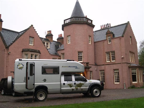
We decided to try for a luxury night just before Inverness so we looked up the Lonely Planet and saw that a place called Birchcrew House was available for a bargain ₤170 per night. That would do us as we had been saving money by parking in camping areas and off the road. We booked into the Kessock Suite in Birchcrew House and learnt that the house was built in the 1600s and was located on Beauly Firth about 5 miles to the west of Inverness.
The GPS is extraordinary. We had telephoned Birchcrew House and they gave us the address, we keyed it into the GPS and in rainy darkness, it took us through the streets of Inverness and over the Caledonia Canal. Unfortunately, as we got to the entrance Dick missed it in the dark, so we had to reverse and do an almost impossible turn for such a big vehicle back into the hotel entrance gates.
Bunchcrew House, now a hotel where we stayed overnight with our Earthroamer parked at the front
After settling in we went down to the drawing room for Dick’s favourite drink, a Pimm’s in front of a roaring log fire, and gave our order for dinner – Scottish beef of course with New Zealand wine.
365kms Today 15,406kms Total
Click here for the next day – the last of Stage 3.
Click here to return to the Smith’s Overland main index page.